About 10 percent of the world’s population live in coastal areas that are less than 10 m above sea level. Despite the urgent need to monitor coastal waters, in situ measuring stations, including wave buoys, do not provide sufficient insight into coastal water level variations. In particular, they cannot provide sufficient information on the so-called Significant Wave Height (SWH), which is an essential property of water surfaces. Satellite altimetry (the determination of the water level by means of satellites), plays an increasingly important role here. Over the open sea, the values determined by means of satellite altimetry are very reliable. Over coastal waters, however, the situation is quite different. Here, headlands, ships, and other disruptive factors make determining the SWH more difficult and inaccurate.
Original publication
Gou, Junyang; Tourian, Mohammad J. (2021) RiwiSAR-SWH: A data-driven method for estimating significant wave height using Sentinel-3 SAR altimetry. In: Advances in Space Research, Elsevier, Volume 68, Issue 12, 15 December 2021, https://doi.org/10.1016/j.asr.2021.12.019

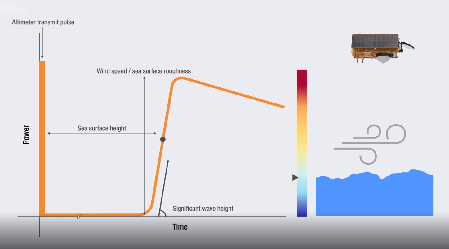
Calculating the SWH by means of satellite altimetry works as follows: The satellite transmits signals during the overpass and receives them back, resulting in a waveform (a time series of the reflected power). The slope of the waveform is linearly related to the SWH of the sea surface and allows scientists to estimate the SWH by determining the slope (see figure and video). In the new altimetry concept, the so-called SAR altimetry, a burst of signals are sent, and the satellite then receives back not only one signal, but a whole set of signals from every single point of the area being covered on the earth.
All signals or data from a particular point are then bundled into a so-called stack. Here, the linear relationship no longer applies, and the SWH can only be determined by means of a highly complex modeling. “This method is very complicated and, moreover, there are no reliable wave height results for measurements near the coast,“ explains Dr. Mohammad Tourian from the Institute of Geodesy at the University of Stuttgart. This led him to consider how measurements near the coast could be performed more easily and with better results.
The new measurement method is simpler and more reliable
Mohammad Tourian looked for a relatively simple linear relationship in the SAR altimetry measurement, between the waveform characteristics and the sea wave height. He found it in the width of the waveform: “The steeper the slope and the broader the waveform, the higher the waves are on the sea surface.” By this means, over the open sea and over coastal waters, wave heights can be estimated in a relatively simple way. The next step was to check whether this assumption is true and whether the calculation method leads to a reliable determination of the SWH. For this reason, Tourian assigned a study to the student Junyang Gou as part of a Bachelor’s thesis.

Proof of concept is provided
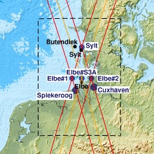
In the study, Junyang Gou investigated the data-driven method of finding the SWH using the data from the Sentinel-3 satellite, for waves both on the open sea and near the shore. He compared the data of gages and virtual stations along the North Sea coast, including those near Cuxhaven, Spiekeroog and Sylt, as well as data from conventional methods, with the data obtained on the basis of the new method. Validation showed that relatively reliable estimates of the significant wave height are possible. The new method led to the SWH with an accuracy of 0.25 to 0.91 meters for different locations in the North Sea. It is thus 40 percent more reliable than existing methods. “We have employed our method over different regions in the coastal zone of the North Sea and validated it. The method yields reliable SWH values for locations up to a distance of 1 km from the shore: The proof of concept is thus provided,” says Dr. Mohammad Tourian.
The data is important for predicting tidal surges and tsunamis
Originally, the altimetry missions of space agencies were launched as research satellites. Since 2016, Sentinel data has been used not only for research purposes, but also for everyday activities. For example, it is passed on to port authorities and the shipping industry, or it is used for weather forecasts. Reliable data is important for predicting tidal surges and tsunamis as well as for gathering information on ocean currents, on sea level changes near the coast, and after earthquakes. In this way, last but not least, possible consequences of climate change will become visible. “This becomes possible by means of long-term measurements. For example, there are coastal regions where the sea level rises by 10 cm every year,” Mohammad Tourian explains.
He hopes that the new calculation method will be implemented as one of the standard methods for Sentinel data. He also plans to apply for an appropriate grant from the ESA during the year.